Land Cover Change from the 2020 Midwest Derecho
by Emily Barbini
Synopsis and Abstract
On August 10th, 2020, a long-lived, line of thunderstorms known as a derecho ravaged through the Midwestern United States. While derechos are prolific producers of damaging winds, this particular system generated wind gusts of 140mph at its peak intensity. As a result, over $11 billion dollars in damages were incurred from Nebraska to Indiana, alongside many injuries and four deaths (National Weather Service, 2020).
Ever since its inception, the field of Remote Sensing has proved vital to meteorologists all across the sector. In addition to RADAR technology, satellite imagery has played a key role in operational duties such as forecasting and issuing warnings. It also serves as a tool to find areas impacted by storms that may have moved through gaps in radar and/or storm-spotter networks. Few studies have performed an in-depth exploration of the usefulness of imagery from satellites regarding damage from severe weather events. For example, as spectral signatures from areas damaged by tornadoes are similar to those damaged by fires, the same techniques can be used for analysis (Kingfield and Beurs, 2017). The 2020 Midwest Derecho caused widespread, severe damage to crops; hence its impacts can be detected via satellite imagery. This project seeks to find a "scar" left behind by the storm in Landsat 8 imagery and compare it to the approximated damage swath found in the NWS Damage Assessment Toolkit. To further verify the effectiveness of the imagery, local storm reports from the NWS Storm Prediction Center archive will also be utilized. To maintain simplicity, only the area where the storm was at its peak will be analyzed. With the newly increased temporal frequency granted by Landsat 8 and 9, meteorologists in the National Weather Service can obtain an image more quickly to possibly detect areas left unsurveyed in the wake of any severe thunderstorm event.
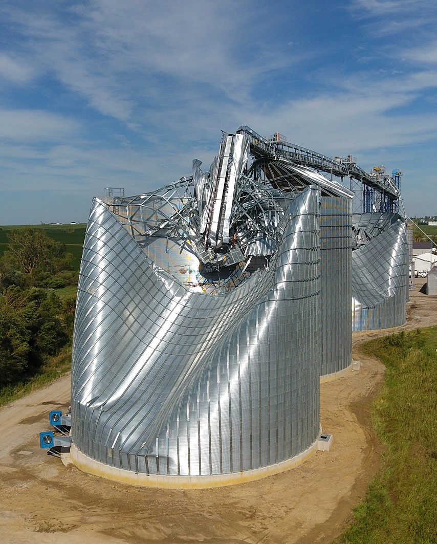 Image I. Damaged Grain Bin, Credit: Kip Ladage
Project Goals
The project goals are as follows:
- Use supervised classification to estimate landcover changes as a result of the storm, namely where it was at peak intensity
- Assess the best indices to use for analysis concerning damage from linear thunderstorm systems
- Verify assessments with storm report data and damage swath estimate from the National Weather Service
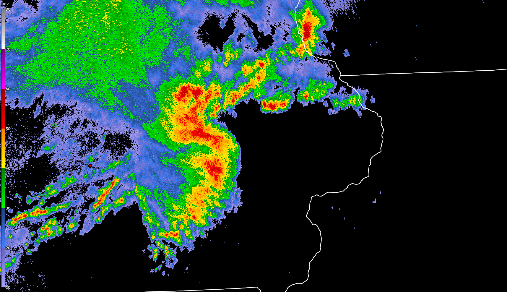 Image II. Radar Reflectivity Scan of Derecho at Peak Intensity near Cedar Rapids, IA
Process
Due to the unique location of the study area, this process involves four Landsat 8 images. Thus, an eastern image and a western image are necessary to analyze the land cover before and after the storm.
The steps to process the images taken before and after the storm are as follows:
- Obtain Landsat 8, Collection 2, Level 2 Imagery of Eastern Iowa via the USGS EarthExplorer site. If necessary, collect an additional image to supplement any images that have some cloud cover.
- Collect storm reports from the Storm Prediction Center.
- Obtain the damage swath estimate from the NWS Damage Assessment Toolkit. Use only the attributes of where the damage was analgous to a tornado rated EF-2.
- Use ArcGIS Pro to create an extent shapefile.
- Use R to create a workflow similar to Lab 4 to mask clouds from the images.
- Normalize any supplemental images.
- Normalize the original eastern image to the western image.
- If applicable, use an if-else statement to fill in the NAN values on the normalized original images, using the normalized supplemental images.
- Crop the normalized images using the extent shapefile.
- Save the cropped, normalized images as multiband raster .TIF files.
- Use ArcGIS Pro to obtain 30 supervised classification samples for each of the 6 classes- Water, Urban, Healthy Vegetation, Unhealthy Vegetation, Trees and Bare Soil. Export each set of samples as a shapefile.
- Run the Maximum Likelihood Classification function for the before and after image. Save the resulting classifications as .TIF files.
- Return back to R to evaluate the changes between the two with a similar workflow as Lab 10.
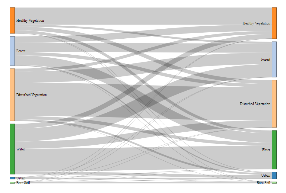
- Use the resulting change_ha.csv file to create a Sankey Diagram.
- Use ArcGIS pro to explore the effectiveness of various Landsat 8 indices for viewing damage from linear thunderstorm systems.
- Verify conclusions drawn from imagery (both regarding indices and classification) using NEXRAD data and Local Storm Reports (LSRs) from the National Weather Service.
Observations and Maps
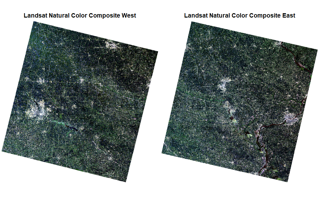
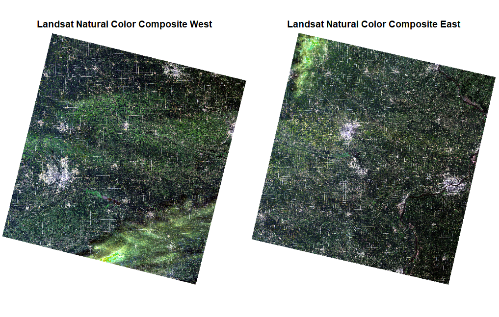
Figure I. Unaltered, Real-Color Composite Landsat 8 Images. Left two- Before, Right two- After.
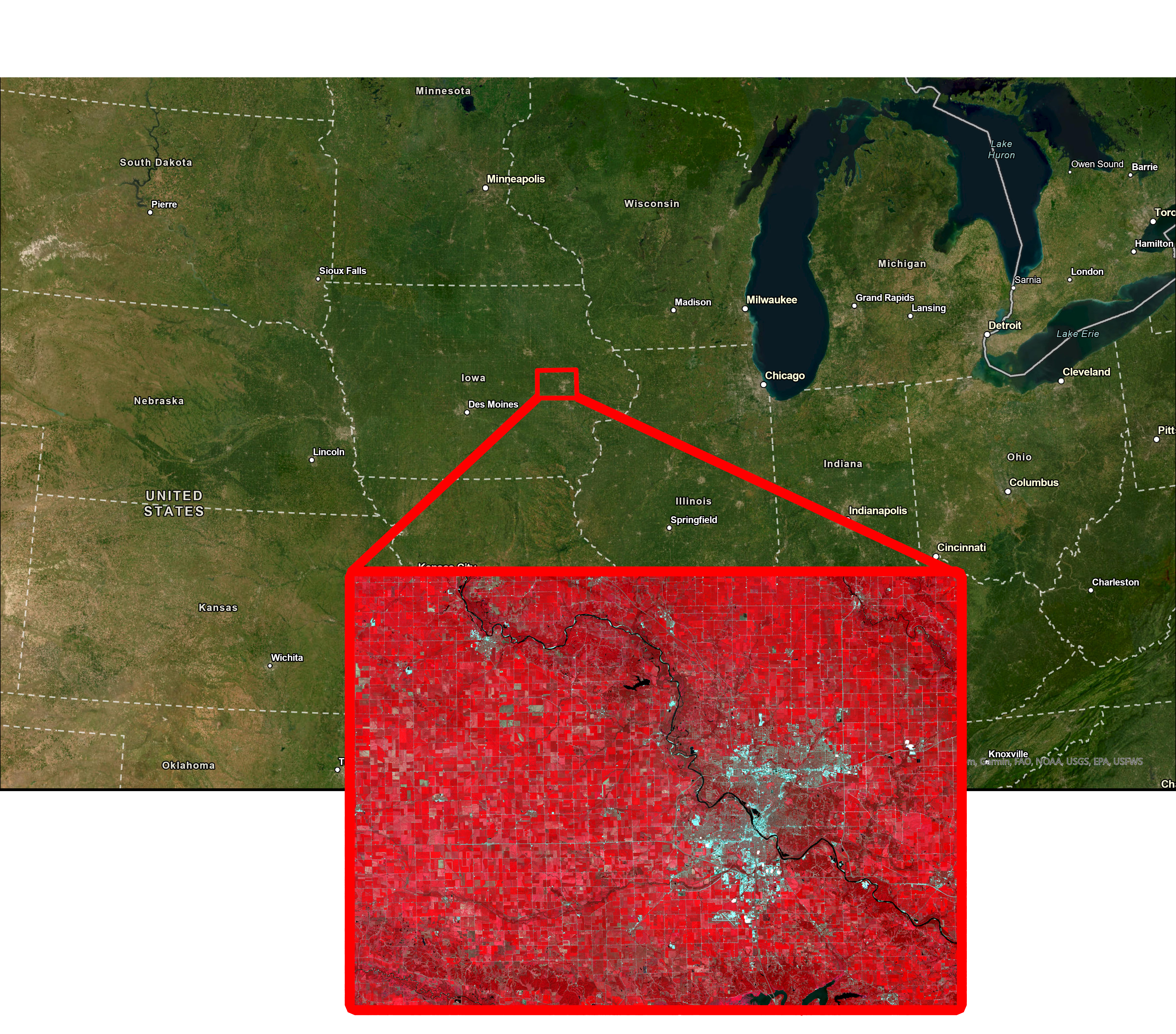 Figure II. Study Area Extent with False-Color Composite “After-Storm” Image
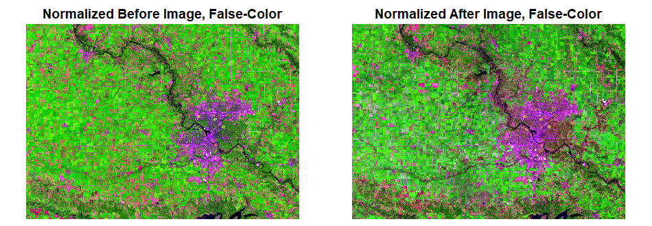 Figure III. Cropped and Normalized Landsat 8 Images
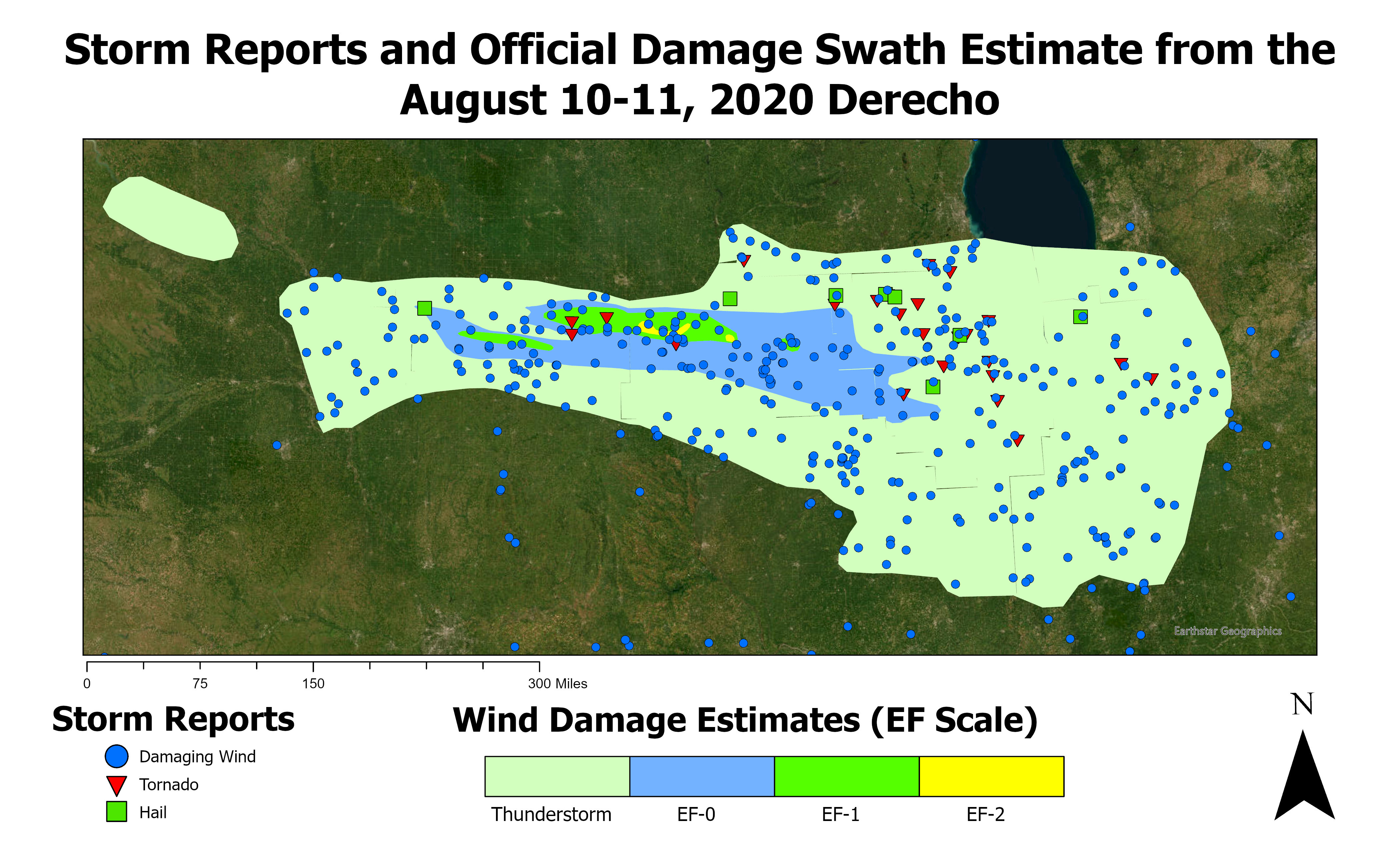 Figure IV. Derecho Damage Swath Estimate and Storm Reports from NWS
Results
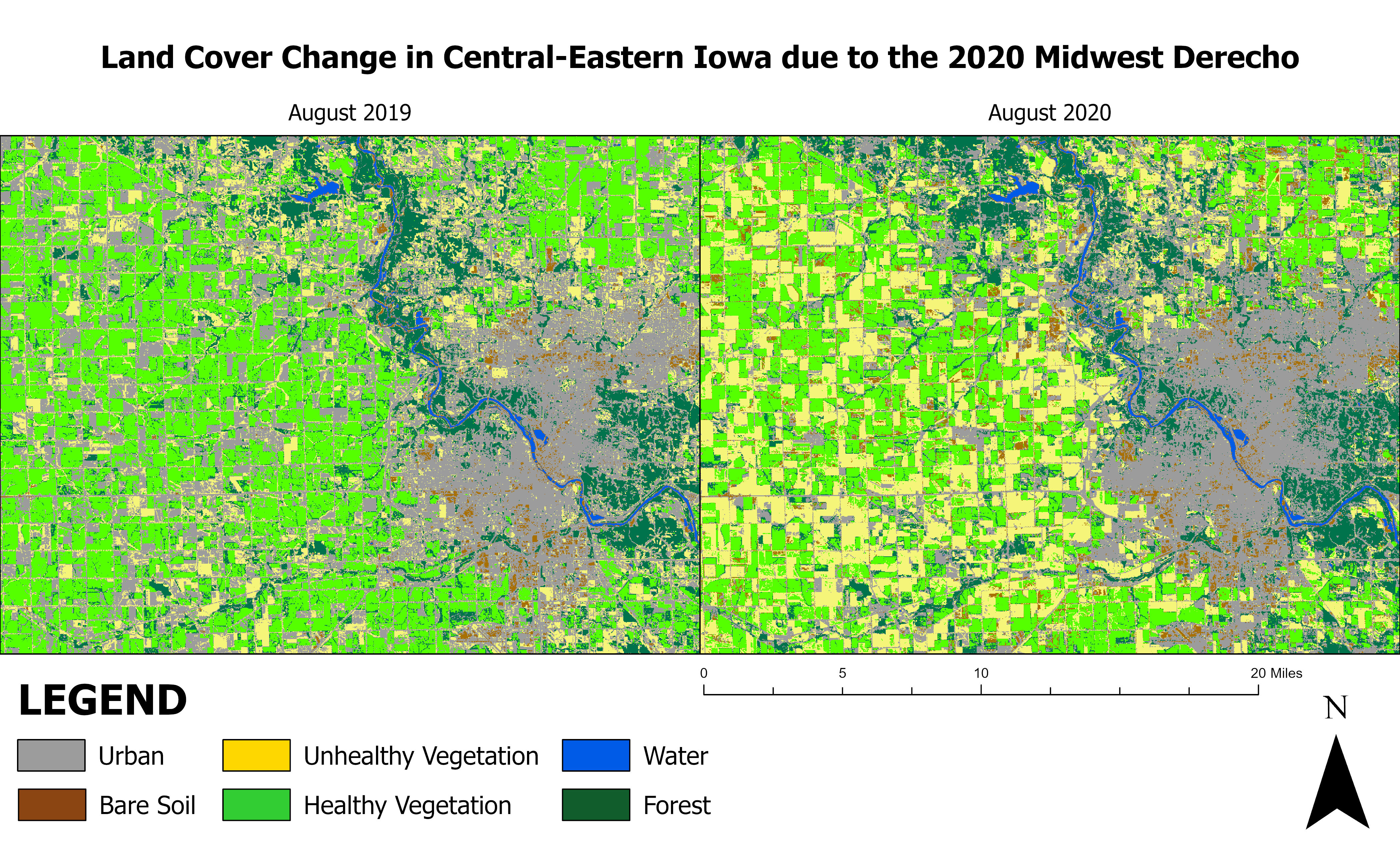 Figure V. Land Cover Classifications
| Bare Soil | Disturbed Vegetation | Forest | Healthy Vegetation | Urban | Water | |
|---|---|---|---|---|---|---|
| Bare Soil | 2064.78 | 99.18 | 15.12 | 47.61 | 917.91 | 504.09 |
| Disturbed Vegetation | 1723.5 | 18016.92 | 12573.36 | 6444.9 | 18503.91 | 1.17 |
| Forest | 690.39 | 3692.88 | 33757.29 | 7317.9 | 5386.59 | 0.63 |
| Healthy Vegetation | 3264.48 | 22426.29 | 5697.18 | 65028.33 | 6246.99 | 0.09 |
| Urban | 5465.52 | 25551.09 | 9151.47 | 13945.23 | 44682.21 | 47.16 |
| Water | 104.13 | 0.45 | 0.18 | 0 | 35.73 | 2479.14 |
Figure VII. Sankey Diagram Table- change_ha.csv
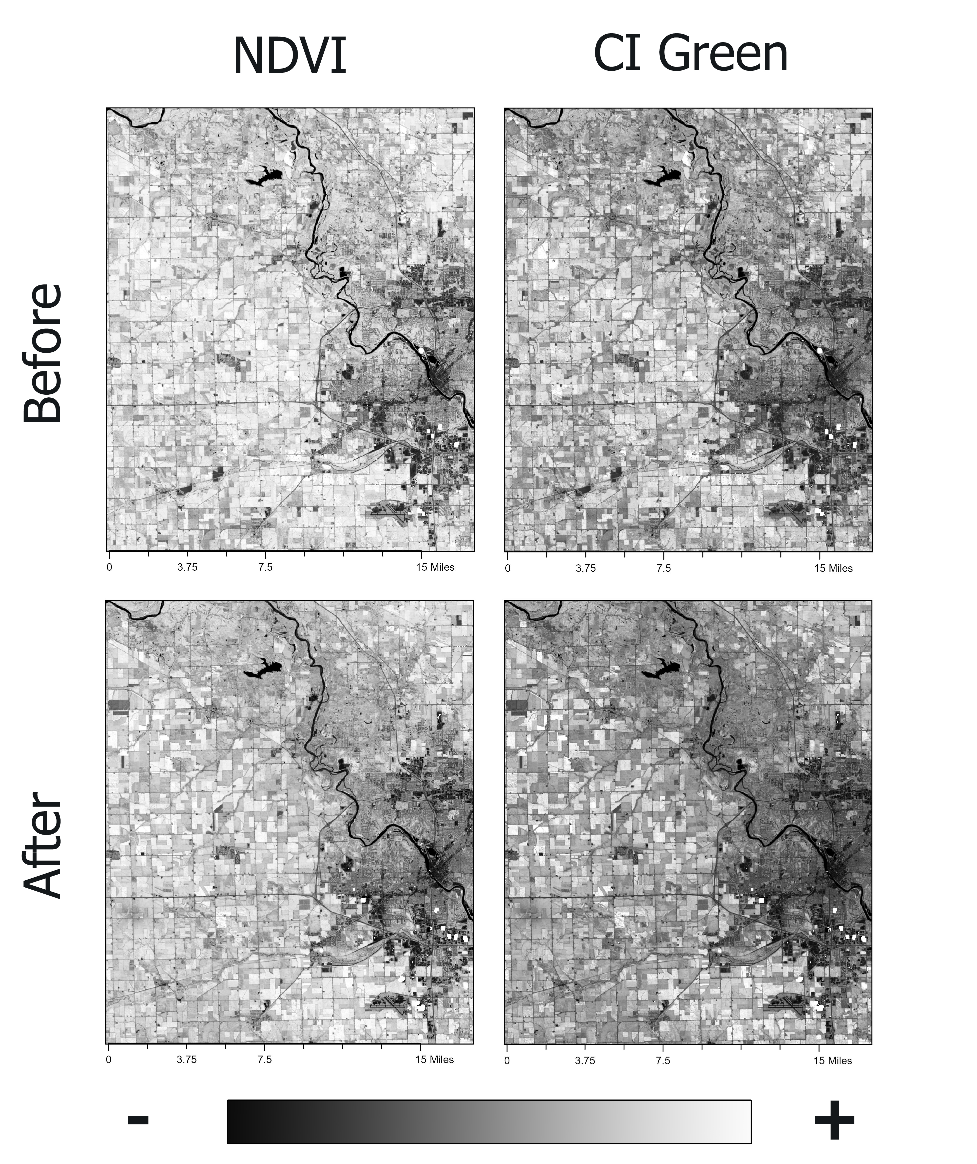 Figure VIII. Most Effective Indices- NDVI and CI Green
Findings
As the 2020 Midwest Derecho infamously left widespread impacts, Figure V visually highlights the damage done to cornfields and trees around the city of Cedar Rapids. In addition, the visible expansion of Urban classes into areas formerly occupied by Tree and vegetation classes indicate damage such as fallen trees in Cedar Rapids. However, the Sankey Diagram (Figure VI) does not show much drastic changes regarding healthy and disturbed vegetation. The greatest changes appear to be pixels classified as Water and Disturbed Vegetation in the "before" image, changing to the Forest classification in the "after" image. This can likely be attributed to a number of factors, such as a poor sampling method, the river having less water content, or differences in rainfall amounts. The unusual statistical results could also stem from differences in spectral signatures as the images were taken appproximately one year apart from each other. Regardless, these assessments have indicated that improvement in classification methods is necessary.
When assessing the effectiveness of NBR, NDVI, CI Green, SAVI, NDBI and MNDWI, it was found that three of these indices were the most effective at detecting impacts left by severe weather (see Figures VIII and IX). NDVI, CI Green, and NDBI involve wavelengths that storm damage often presents a higher reflectivity (Kingfield and Beurs, 2017). NDVI was best for determining derecho-related damage to trees, especially inside the and around the city. CI Green had a similar performance, except with trees and crops in the rural areas. On the other hand, NDBI presented an unexpected result- it emphasized a few signatures that resembled damage left behind by tornadoes instead of straight-line winds. One was verified to be a tornado scar via radar and storm reports. However, a feature southwest of Newhall, IA prompted further investigation as it could not be attributed to the derecho. The online Tornado Archive map explorer showed no tornado in or around this feature. Imagery taken in the weeks leading up to August 10th, 2020 indicated that the feature was created by a separate severe thunderstorm event.
On July 11th, 2020, numerous supercell thunderstorms brought damaging wind gusts and hail larger than 1 inch in diameter to parts of eastern Iowa. One storm in particular stood out on radar reflectivity- not only was it moving in the same orientation as the feature, but its mesocyclone (rotating updraft that is often attributed to producing tornadoes) nearly overlaid perfectly over the feature. Other data components such as radar-derived velocity data and correlation coefficient hinted at certain tornadogenesis processes occurring. As the feature had no damaging wind, hail, or tornado reported with it, the National Weather Service office in the Quad Cities area was contacted concerning the possibility of an unreported tornado associated with that supercell thunderstorm.
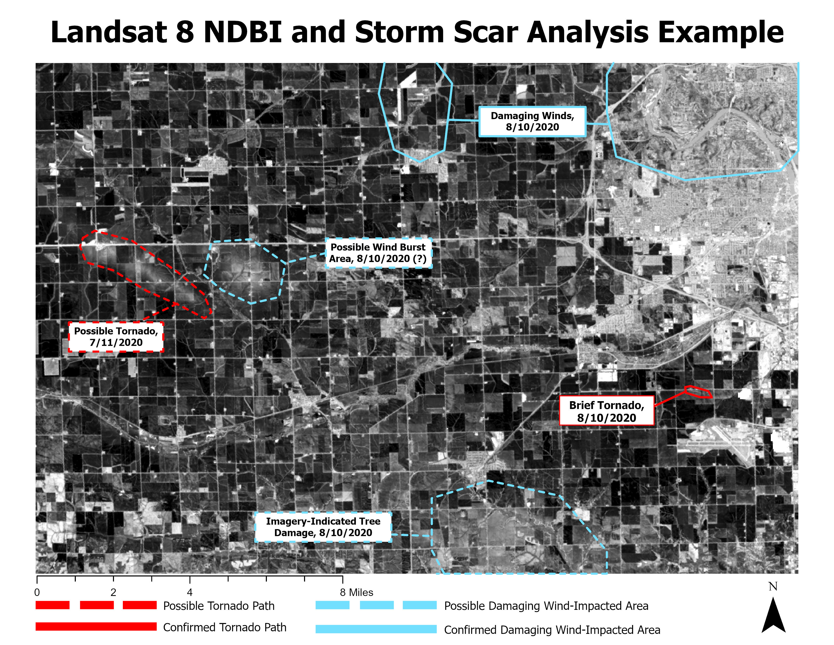 Figure IX. Sample Storm Scar Analysis with NDBI
Conclusion
The analysis of land cover change due to the 2020 Midwest Derecho has provided insights into the usefulness of satellite imagery and GIS techniques when seeking areas of storm damage and impacts. Although the classification methods did not provide as thorough-than-expected results, the assessment of the indices did indeed show a “scar” left behind by the derecho. It appears that a given index’s usefulness regarding storm damage relies on not only the topography type, but also the type of storm. With known index effectivenesses, possible unreported storm damage could be detected and later surveyed. All in all, while the imagery did have some degree of accuracy in assessing locations of possible storm damage, it should never be the sole source in determining where impacts occurred. Remote Sensing technologies should almost always be treated as secondary components of information to back up ground truth from sources such as weather stations and storm spotter observations.
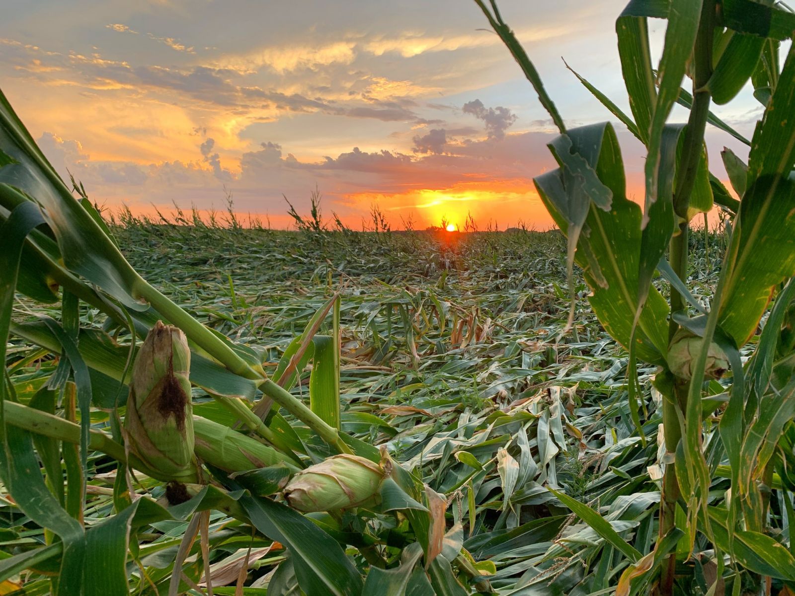 Image III. Damaged Corn Field, Credit: Lisa Schmitz
Works Cited
Data and Articles
National Weather Service. Damage Assessment Toolkit- 8/10/2020. File Last Modified on 8/20/2020. Shapefile. Retrieved [December 9, 2024], from https://apps.dat.noaa.gov/stormdamage/damageviewer/.
“Severe Weather Event: Aug 10, 2020” National Weather Service Storm Prediction Center. Web. Retrieved [December 9, 2024], from https://www.spc.noaa.gov/exper/archive/event.php?date=20200810.
“NOAA NEXRAD Level II Data” National Centers for Environmental Information via Amazon AWS, Aug 2020. Web. Retrieved [December 9, 2024].
U.S. Geological Survey. (n.d.). Landsat 8 [LC08_L2SP_025031_20200820_20200905_02_T1]. EarthExplorer. Retrieved [December 9, 2024], from https://earthexplorer.usgs.gov
U.S. Geological Survey. (n.d.). Landsat 8 [LC08_L2SP_026031_20200811_20200918_02_T1]. EarthExplorer. Retrieved [December 9, 2024], from https://earthexplorer.usgs.gov
U.S. Geological Survey. (n.d.). Landsat 8 [LC08_L2SP_025031_20190802_20200827_02_T1]. EarthExplorer. Retrieved [December 9, 2024], from https://earthexplorer.usgs.gov
U.S. Geological Survey. (n.d.). Landsat 8 [LC08_L2SP_025031_20200703_20200913_02_T1]. EarthExplorer. Retrieved [December 9, 2024], from https://earthexplorer.usgs.gov
U.S. Geological Survey. (n.d.). Landsat 8 [LC08_L2SP_026031_20190809_20200827_02_T1]. EarthExplorer. Retrieved [December 9, 2024], from https://earthexplorer.usgs.gov
Kingfield, Darrel M., and Kirsten M. De Beurs. “Landsat identification of tornado damage by land cover and an evaluation of damage recovery in forests”. Journal of Applied Meteorology and Climatology, vol. 56, no. 4, Apr. 2017, pp. 965–987, https://doi.org/10.1175/jamc-d-16-0228.1.
National Weather Service, 2021. “August 10, 2020, Midwest Derecho”. Retrieved [December 9, 2024] from https://storymaps.arcgis.com/stories/f98352e2153b4865b99ba53b86021b65.
National Weather Service. “August 10, 2020 Derecho.” NOAA, 30 Mar. 2022. Retrieved [December 9, 2024], from www.weather.gov/dmx/2020derecho.
Tornado Archive. Tornado Archive Data Explorer. Retrieved [December 9, 2024], from <https://tornadoarchive.com/explorer/.
Images
National Weather Service. “Radar Reflectivity of the August 10, 2020 Derecho at one-hour time steps”, National Weather Service. Retrieved [ December 9, 2024], from https://www.weather.gov/ind/2020derechoanniv.
Ladage, Kip. “Wind damaged grain bin in Tama County”, National Weather Service. Retrieved [December 9, 2024], from https://www.weather.gov/dmx/2020derecho.
Schmitz, Lisa. “Corn damaged near Adel”, National Weather Service,. Retrieved [December 9, 2024], from https://www.weather.gov/dmx/2020derecho.
Subscribe via RSS

